Denver snowstorm: Answering your questions
Hey, thanks so much for joining us here on 9 News Plus. I’m meteorologist Chris Bianchi. We play a little game here with this upcoming winter storm going to play a game of how much snow at my house, where I answer every question that you’ve got, except for how much snow is falling at your house, because the other people watching probably don’t care all that much. So let’s kind of break it all down for you. First of all, significant winter storms starting up after dark tonight. We’ll see that first snow probably develop somewhere between about 4:00
and 8:00 PM. We’re looking at a widespread 8 to 12 inches worth of snowfall, though a few areas will probably end up with a little less than that. Maybe on the West side of Denver will again break all this down for you, but feel free to send in your questions on Twitter. Feel free to text it to us. Feel free to send it in on Facebook as well. We’re monitoring all those questions for you, and we’ll take them as they come. But let’s give you a quick overview here of what we’ve got, again, answering every
question we’ve got except for, say, after me. How much my house? Alright, let’s get into some of those snowfall tools and what we can expect, he here’s kind of latest statewide snowfall accumulation
there’s that kind of a band right in here, just the East Denver. That’s a little bit higher than that. That’s why I’m even with that computer forecast model in mind. I still think that we’re looking at 8 to 12 inches of snow for probably most of us, certainly along and east of I-25, West of I-25, I think we will see a few areas that end up with maybe 4-5, six inches worth of snowfall. And then again, some spots here, all it takes is a narrow band to sit on up and move its way into the
Denver area to give us some of those really, really high snowfall totals. So that’s what we’re talking about here. Going to start taking some of your questions. And so I’m going to put myself back on camera here because we’re getting a lot of them, by the way, appreciate them. And these are great questions are coming in. First of all, favorite model for snow, the one that has performed best with Adidas so far this season has been the European forecast model. It’s done the best with these types of storms. Especially kind of 3-4 days out. The
European model was the first one on this one. It’s been kind of consistent for the last. 5-6 days at this point that we’re gonna get a storm around now, which is remarkable. That computer forecast model picked up on a storm that at that time was off the East Coast of Japan and said that this is going to lead to in 5-6 days snow for us here in the Denver area. So that is. That is what I would answer at this point for that one. So still getting a lot of these questions coming on in prediction
for impact on metro areas, schools that comes in from Nikki and Longmont, I would think. I’m not a Superintendent, kids do your homework. Even though what I’m about to say, I can’t see how schools are open tomorrow. I can’t. We’re going to have, we’re going to wake up to four or five inches of snow on the ground in most areas even again these lower snowfall totals. So let’s say for example, we only get 567 inches of snow in Denver. Say that’s what we end up with. Most of that comes overnight tonight. So you’re gonna wake
up to 3/4 inches of snow. It’s still gonna be snowing tomorrow morning. It’s gonna snow most of the day tomorrow. To me it seems very difficult to see. If I was a meteorologist advising a school district, I’d say close it tonight, because who are we kidding? If you end up with a foot of snow, it’s going to be snowing most of the day tomorrow. What are we doing sending kids school buses and stuff out and stuff like that? I know we live in a place where we get, what, nearly five feet of snow a year?
We get our fair share of snow, but we don’t, especially this time of year in January. We don’t usually get these kinds of big snow events. So to me, I would say pretty, pretty confidently, most schools be closed tomorrow. But again, I don’t make those decisions. So just keep that in mind. Mountain man Daniel asking a really good question, getting a lot of really good ones. By the way, pretty impressed with this. Why does this storm have so much more moisture than other January storms? What moisture transports are in play? So let’s kind of pull
this up for me to pull up our satellite and radar imagery for you and show you what we’re seeing. So this is HC Doppler radar right now, right. This is kind of the snow that’s moving its way San Juans right now. The main storm is out here into the desert southwest. The area low pressure, let me, let me try and draw this quickly for you here. Our main area of low pressure is right over Northern Arizona, right over the Grand Canyon. And this is a very March like setup. The jet stream is kind of focused.
Over the desert southwest. And that means there’s a lot of energy in play. Again, this is what a map that if I was showing you in March would be saying, oh, this is a classic spring snowstorm. What’s unusual about this is the jet stream is so far South this time of year. Normally it’s a lot further north and it’s spurring. It’s energizing the system that you’re seeing right here, so. To answer your question, Daniel, the only thing I mean only quote UN quote thing that’s a little unusual about this is the fact that the jet
stream is so far South this time of year. There’s there’s a number of reasons that could be in play. We just have a jet stream pattern right now that’s kind of conducive to the jet stream kind of dipping S through the Southwest. Again, that would be the main reason behind it. It is very unusual to see the jet stream S far South this time of year and also so energized the jet stream, what it’s energized by, it’s by temperature differential. So normally in the middle of winter, right, everybody’s cold, right. So because of that in
spring you tend to have still really cool temperatures, for example, up in Canada, North Dakota, but starting to get really warm, kind of like 80s, nineties warm in places like Arizona and northern Mexico. Um, and that temperature gap is what springs the jet stream and kind of strengthens and energizes it. But right now the jet stream is a really strong and B, really far South. Again, something we tend to see more in March, early April, late February, not in the middle of January when it tends to be really cold for just about everybody. But again,
that’s a really good question to, you know, again, I’ve got more coming on in, more of these good ones coming through. So that’s one answer for you and somebody says they’re driving. From across the metro area tonight at 8:30. I’ll kind of bring this on out. Again, the whole point of this is that we’re not answering how much. So my house, what exactly for my exact situation that we’re broadening things out. I’m going to walk you through the forecast here, so for tonight. What we’re likely looking at is the snow kind of developing. In fact,
let’s kind of zip this on in a little bit here. The snow develops somewhere between about 4:00 and 8:00 PM, as I mentioned. So by about. Eight, 9:00 o’clock tonight that snow is gonna be coming down for you and maybe kind of one of the issues with the snowfall for tonight and one of the things that we’re still working through in terms of the forecast is the snow will fall as it falls. It probably won’t stick initially, but once it starts to stick, you know, bam, you might remember that December 28th snowstorm won’t be quite
as intense as that where we had three inch per hour snowfall rates. But what will probably happen is we’ll get that snow initially to fall and initially it won’t look. All that bad for the first hour? So and then Bam, where you get a nice band of snow, move its way on through. We’ll get a quick inch of snow and we’ll turn the roads from mostly wet at say 7:00 or 8:00 o’clock to an inch or two of snow on the roads and make it really, really slick in about an hours time. So one of
the things we want to emphasize is that those road conditions going to go downhill really, really quickly, so it’s just worth noting that again. Even though if you head out you wanna you take the gamble or something like that, try and make it somewhere you can get home pretty easily. I would say a normal drive 5 minutes or less. If you need to go to the corner store, go fill up on gas and like that and the roads look OK, you probably are right. I would really advise against driving from one side of town to
the other. From Parker to downtown or something like that. After about 8:00 o’clock tonight it’s going to get pretty nasty pretty quickly. Again the exact timing. Still working through that a little bit, but I would plan on things. And downhill around 8:00 or 9:00 o’clock after dark tonight. So that’s one thing. I’m getting a lot of questions here about the airport, and that has been a common question about this. Only Mabel’s asking this on Facebook about the airport. Specifically, how do I put this politely? The airport is going to be most likely an unmitigated disaster
for tomorrow. That’s about as politely as I could put it. I would not plan on being able to fly out tomorrow if you have a flight in or out of DIA tomorrow. I I would. I would hedge your bets and just move it to Thursday morning, but by Thursday morning we should be back to pretty much normal operations at the airport. Maybe maybe late tomorrow, maybe, maybe late tomorrow night, things start to get back to normal. But the airport is situated in an area where we’re likely going to be looking at those highest snowfall totals,
so along an east of 225. So kind of think Aurora, Commerce City on East, that’s where we’re probably going to be getting this kind of narrow snow band move its way out through. The big question about the forecast right now is it does it move to downtown. Does it move to the West side of the metro area? I feel more confident and I think my colleagues, meteorologist Greg Perez quite reppenhagen who are around right now, we’ve been kind of saying that that we think that that snow band is going to get really close to downtown
Denver. Whether or not it does get us, that means the difference between 6:00 and say 10 inches worth of snowfall. But I do feel pretty confident going hit the airport. So I think the airports looking 910 inches if not more than that worth of snow fall out there. So the impacts the airport are going to be all day long. Let’s kind of pull up. I have a kind of a separate graphic kind of speaking about this here. So the the worst of those impacts again will be tomorrow morning. So if you flight tomorrow morning, forget
about it. No other way to put it again, I’m sorry come across this brush. If you got a flight tomorrow morning, I would just about say forget about it, move it. If you can get out tonight, I think flights tonight could be OK until about again eight 9:10 o’clock and then once we start getting those inch per hour snows. But most of the flights tonight should be alright I think the day part hour flights tonight again you got a flight that’s taken off at 6 even 7:00 o’clock. You’re probably getting out and pretty close to
on time most likely. Once we get to about eight 9:10 o’clock tonight that’s when things start going downhill. That’s when again things start getting real at the airport I think. Tomorrow morning the airport will technically be open. It’s gonna be one of those situations where it’s technically open, but not much is going to be getting in or out of the airport. Maybe a couple of flights here and there. But I would plan on your flight being cancelled tomorrow morning. Tomorrow evening. I think at best you’re looking at a major, major delay, but that is going
to be a best case scenario. Even lots of flights cancelled. I’m sorry, I I know I don’t mean to make light of this. I know this is impactful. I don’t know the situation behind your travel, your air travel, maybe your family coming in. I get it. I’m not trying to make light of it. I’m just trying to say realistically you’re probably not getting in around at the DIA tomorrow. Best case scenario, you’re looking at multiple hour delay. That’s if the storm is on the lower end and that’s if the storm clears out by one 2:00
o’clock tomorrow afternoon, then maybe tomorrow night. We are looking at some flights again, in or out with major delays. That is a best case scenario, most likely your flight. You’re flying out of the airport. Tomorrow is going to be cancelled. Sorry again, I don’t mean to make light about that. So this is another really good question. Gosh, getting lots of, I’m really impressed Lance is asking why the Greeley area is currently in a snow hole. So let’s kind of talk about some of the the dynamics in play here, so. I’m going to pull this graphic
back up and show you the forecast here. Right in northern Weld County there’s a little bump in elevation called the Cheyenne Ridge. This storm is going to be featuring winds coming out of the north and out of the east. And what that means is there’s a northerly component to the wind, right? There’s a little Ridge about 5700 to 6000 feet elevation right on the Colorado, Wyoming state line. A lot of you have heard of it, the shine Ridge, as those winds go down off of the shine Ridge, they downslope, they’ve warmed, they accelerate, they dry
and they warm. So this, that’s why. Not here in Weld County might notice that little kind of patch of Gray while it’s a little darker than other areas, that’s that little influence of the Cheyenne Ridge that is downsloping and warming and leading to slightly less snow for those areas. So that’s why really you often will see a bit of snow hole out there on a by Ramer Grover. Those areas there that are just the South of the Shine Ridge, you tend to feel those slightly slower or lower snowfall accumulations because of that. But one thing
I also want to get into is. Because the uncertainty of this forecast, we’re trying to communicate this as best as we can. So I kind of want to emphasize the fact that there is uncertainty here, folks. And this is not to, you know, I don’t know, just to say, look, there’s there’s a realistic scenario here, folks. It’s not, I’m not just saying it to cover myself here. I’m saying that there is a realistic scenario where if we don’t get the banding from this snow, we end up with five, six inches of snow, maybe even 4
inches in some of those lowest areas, which may feel underwhelming compared to some of these forecast snow totals. But there is a realistic scenario. In fact, I would guess somebody in the metro area is only. Only going to have 5-6 inches perhaps on the West side of town. And then there’s other areas where if we get the banding that sits over the same area again and again, maybe up by the airport east side of Aurora. You know, the Centennial on E 225, certainly 470 on East Strasburg, Bennett, somewhere like that. Something would come in with
131415 inches worth of snowfall as well. And let me kind of detail this in a little bit more for you. So hopefully this answers it for us. In fact, there’s going to be these just kind of narrow bands that set on up and it’s to get a little geeky about it, something called a deformation zone. So when you get an area, low pressure kind of forces the air to rapidly rise. Right. That’s rising motion is what creates snow, what creates precipitation. And you get these kind of narrow bands where the air is kind of stretched
out a little bit more than usual. And it’s usually follow me here. I promise I won’t be too nerdy about this. It’s on usually on the northwest side of an area of low pressure, so you get that little bit of extra stretching, but it’s usually kind of a narrow band, maybe 50 to 100 miles wide, where you get this just kind of extra intense band of snowfall and where that sets up. Is gonna determine again who gets 121314 inches versus only 567 inches worth of snowfall. I think I feel very confident that just about everybody’s
going to see at least a medium sized snowstorm. Again talking 5-6 inches plus the question specifically for downtown Denver in a lot of areas on the West side of town, are we talking A567 inch Snow Storm which is within us? Sneeze out here folks, that’s something or we talking about. Something that’s a bit more. Than that are we talking about, you know, perhaps record-breaking stuff and we’ll get into that here in the next few moments. Let’s get some more of these questions because we’ve got a lot of them coming in and I appreciate them because
I’m again, the whole point of this is not answering how much snow in my house because I’m not answering those questions. And you guys have been awesome asking all sorts of the right questions that you should be asking right now. So I really, really appreciate that and that’s a credit to all of you out there, so. JC is asking that he works for the VA in Golden and to drive from Brighton for tonight. Again, just getting to those driving conditions, I’m trying to avoid some of those specific exact area sorts of questions. If you’re driving
across town tonight, trying to do it before 8:00 o’clock or so, if you get to 8 nine o’clock again by let’s say at 8:30, the roads might be just mostly wet, may be barely snowing. It’s going to go downhill pretty quickly. Especially after dark, we won’t have the sunlight coming down and keeping the roads relatively warm, it will stick pretty quickly. So once we get that first band of snow in there, you know, bam here to go from just a little bit of maybe wet slush out on the roads to an inch or two of
snow in a very short time period. And that’s going to slow those roads down quickly again. Remember, if you were driving on that night of December 28th, just a couple of weeks ago when we had that intense snow storm, we had people here in the building sitting right over there who were just telling us. That was the worst drive home they ever had. I don’t think it’s gonna be quite that intense. We’re not gonna be talking about 3 inch per hour snowfall rates like what we had then, but it’s gonna go downhill pretty quickly. So
yeah, if you’re driving across town, get that done before 8:00 o’clock. You know, ideally earlier than that. But let’s play a time a little bit here I think before he should be. All right, once we get to about 8-9 o’clock here, folks, that’s when things start going downhill. Another question. I’m getting pretty, pretty. Commonly, and again I really do appreciate these questions because you are asking this is what I had in mind. This is exactly what I had in mind when we set this on up. Not, not the. I feel like every time that’s before,
it’s always like how much in Westminster, how much in Thornton, how much in Highlands Ranch, and that’s not the question we’re trying to answer here, but this is the right question and I’ve seen three or four of this already. Will this be as wet as the snow event that we had late last month back in late December? The answer is. It won’t be quite as wet. I’m trying to think the least geeky way to say this. There is for the same amount of snowfall. So let’s say you get a foot of snow. Let’s say you
get 12 inches worth of snowfall. The amount of water content that’s within that, it differs. So for example, think about how heavy water is. If you’ve ever had to change out the water cooler at work, you know, lifting up that thing of water, it’s really, really heavy. So the amount of water that’s within that snowfall is really important. That determines you can have a 12 inch snow. And there is not actually a ton of snow within it or not, not a lot of water within it. So it can be a relatively light 12 inches of
snow. This upcoming snow event, long winded way of saying it looks like it’s going to be a medium to high-end heaviness to that snowfall, not. As heavy as what we had back in late December, that was an exceptionally heavy wet snow. But in some cases we may end up with more snow from this specific storm system. But the water content will be slightly less than that one, if that makes sense. So it’ll probably be relatively similar in terms of the impact, in terms of the heaviness, in terms of shoveling. I don’t think we’ll see quite
as many power outages or things like that from this upcoming storm system, but we will have some fairly. Again, this might be one of the snowstorms if you’re older, 60 plus heart issues, back issues, things like that. If you’ve got the money or disposable income for, it might be the snowstorm to pay the next door neighbor kid 20 bucks, 25 bucks, whatever it is now to go come shovel your driveway. This is probably a good storm for that. If you can only do that maybe once or twice a winter, this might be one of those
ones because. We’re again looking at a fairly high liquid amount of within that snowfall, probably looking at 3/4 of an inch of liquid. That’s a lot for us here in Denver. Remember, we’re in the high desert after all. So there’s a fair bit of precipitation, fair bit of water within there, probably not quite as cementi as that strong a couple of weeks ago, but pretty close to it. In some cases, we may end up with more snowfall totals than that. So good question. I’ve seen that from AJ and a couple others, so just worth noting
that. Lance, asking another question here that I find quite relevant, will there be any ice underneath all the snow? Probably a little bit. Initially. We’ll probably get just a little bit of freezing. But what will probably end up happening initially is those temperatures. Right now we’re at what, Greg, we’re at 40 right now. What’s that? Are we at 40 right now in Denver? Let’s actually pull it up. I could pull up. Yeah, we’re at 3333. 34 right now at the airport, so I just pulled out you’re right now, so we’re we’re pretty chilly right now,
but we have a fair bit of sunlight that’s coming down on the pavement. So that’s going to keep the ground relatively warm initially, which means that that snow that first falls will probably not stick and that means we’ll obviously turn to water, but pretty quickly that snow will start to stick especially after dark tonight. So point being there probably will end up being a little, not a huge amount, not as bad as the storm from last month, but there will probably be a little lid. Of ice and then we’ll get that snow on top is
something to watch for is there could be a little bit of ice mixed in there as well. Just really appreciate by the way, all these questions continue to come on. I’m going to take a couple more and then get on out of here and stop blabbing here for the next couple of minutes. But again, a lot of great questions that continue to roll on in just pulling them up here. So give me one second. Ooh, this is getting specific. How nerdy do we wanna get? Alright, let’s get nerdy. So Jerry’s asking will a barrier jet.
I’ll explain this here in just a second. So this is confusing. I’ll explain it. Will a barrier jet set up an enhanced snowfall along the Front Range? All right, I probably spoke a foreign language to a lot of you when we’re talking about a barrier Gen. let’s pull up a good graphic for this. So give me one second and I will get you a good graphic to explain. The barrier jet and what could potentially be coming here tonight and this is actually an important part of the forecast. OK. So wind direction matters when we’re talking
about a snowstorm here in Denver, there’s how those winds coming out of the north and east that is an ideal setup for us here in Denver, normally here in Denver, and it’s the reason it can smell in a not so pleasant way right before a snowstorm, is that wind, that wind comes out of the Northeast and it’s coming from the catalogs and, well, Morgan counties. And as a result of that, we’re often getting that smell and dating us here in the Denver area, but that’s usually an indication. That we’re getting that northeasterly wind, which is
ideal for snowfall here in the Denver area. Now what happens, you can actually see that barrier jet perfectly here. When that wind comes up against the Rocky Mountains, it is forced to turn in a certain direction, right? So if you get wind that’s coming up against something, think about, I don’t know, just going to a computer screen. That wind, as it hits the computer screen, has to go in a certain direction. That’s what happens when that wind comes up against the Rockies, it is forced to turn left. And what that does is it creates a
little funnel of wind, which can lead to snowfall banding, and that’s what we’re likely going to be looking at. That’s a barrier jet. It’s a bit more complicated in that, but to just reduce the amount of nerdiness and to make sure that you’re not falling asleep there behind your computer screens and your TV’s there. The again key component is that you get the wind going against the Rockies and as force rapidly turned, so that’s why you see this wind here right over downtown Denver basically turns north-south. And that’s because again the winds being forced to
go up against the mountains, it turns South and that can lead to that narrow intense banding that sets up sometimes in these snow events. So that could could lead to some localized banding and in fact you can kind of see that here. This is the computer forecast model, the European computer forecast. Which again, it came in notably lower with some of these snowfall amounts compared to what we’ve been seeing over the last a while. I think this is on the low end, so don’t take this to the bank or anything like that. But notice how
Boulder, Longmont, Fort Collins, Golden, Evergreen, a bit more in downtown Denver. That’s that barrier jet. Again, that little, little narrow area of strong winds that could lead to some localized banding within that zone. So just worth noting, but that is fantastic. I’m going to kind of. Something’s up here because I think we’re starting to get some of the same questions again and again, which is I think my sign and my indication. All right, shut up already, Chris. So let’s kind of sum round things on out for you. So #1 snow develops between about 4:00 and
8:00 PM tonight, probably looking more and more like we’re going to be towards the end of that heaviest snow overnight tonight between about midnight. And about 8:00 or 9:00 tomorrow morning. So the commute tomorrow, I hope it doesn’t exist. I hope everybody’s staying home, hunkering down, listening to us. Tomorrow mornings commute will be either nonexistent, hopefully or a complete disaster. It’s one of those two things will gradually start to improve as we head through the morning hours tomorrow. By about 1/2 o’clock most of the accumulating snow should be over and done with. By mid to
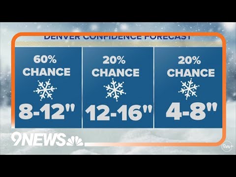
late afternoon we should be done with basically all the snow at that point. Snowfall totals. I’m going to pull this graphic back up for us here, and this is just for Denver. I know, I know, some of us asking about different places I got X amount of time, so I just don’t want to. I don’t want to belabor it, but the way I put it, instead of saying this is how much we’re gonna get, I think there’s a 60% chance we end up with between 8 to 12 inches, probably on the lower end of that,
probably 789 inches for most of us, 20% chance we end up with more than that, which is a realistic possibility. And there is a realistic possibility in some areas, as we just showed you that computer forecast model that came in with lower than that with four to 8 inches worth of snowfall. So again, just want to reemphasize the fact that there is, as always here folks, a lot of uncertainty. And one final thing I want to leave you with is that this is an unusual time of year for this to happen. Normally we get a
big snowstorms. If you’ve been here for a long time, you know this, it’s late February, it’s March, it’s April. We’re getting this in the middle of January, which is very unusual. And if we get 10 inches or more of snow falls and mentioned that is a very reasonable possibility here, that’d be a top five biggest January snowstorm on record. By the way, all we need is 7 inches worth of snowfall for this to be our biggest January snowstorm here in Denver. It was 1992, so 31 years. So this is a pretty unusual storm for a
number of different reasons. A lot of water with it for a time of year. We’re not used to getting it. We had that a couple weeks ago. We’re getting it now. And there’s high variability. Again, some spots 5-6 inches, other spots 121314 inches and that spans the metro area. So a lot of impacts to a lot of folks. The airports I would anticipate tomorrow is going to be if you’ve got a flight tomorrow morning. You don’t. Sorry again, I don’t want to make light of those of you with different plans. And I I don’t mean
you get my point here. You’re not going in or out almost for sure tomorrow morning. You got maybe a chance of getting out tomorrow night and if so would be with major, major delays. If possible, I would hedge my bets and move my flights if it’s something movable or somebody who’s maybe hopefully understanding. Again, I don’t know your exact situations. That’s for you to determine. But I would try and move it to Thursday morning. You should. Things should be pretty much back to normal by Thursday morning, but tomorrow it’s gonna be a mess. I mean,
the airport will technically be open, most likely, but not much to be getting in or out. They may have one runway operating, maybe a handful flights here and there. That’s probably what’s going to be the situation for us at DIA tomorrow. I would plan on your flight being cancelled. I’m sorry, I know I just had to deal with the whole Southwest thing myself. I know the pain of what that’s like. It’s not pleasant, but I’m sorry about that. But just don’t plan on getting in or out dia tomorrow. I would expect schools to be closed
tomorrow. I also think that as well may see some of those rolling in later on tonight. If I was a Superintendent, which I’m not, I would advise that to be the case. Hopefully that’s answered a lot of your questions. I got a lot of awesome ones. I really appreciate them. I appreciate you for watching. Stay safe. Hey, 9 news and chill tonight. Just stay in. I don’t know. Get some good comfort food, plop on the couch, watch. Updates for you. By the way, we’re gonna have extended coverage here. 9 news all day tomorrow, so you
know we’ll be with you throughout the course of this storm tracking it for you right here. But thanks again for joining us and hopefully I’ve answered all of your questions. Stay safe and have a great rest of your Tuesday.