DFW Ice Storm Warning: What does that mean?
OK, let’s go over to Greg. You see the radar behind us. So you said this is really gonna pick up about 7:00 o’clock this morning, sort of like we saw yesterday, but they’re already spaces or excuse me, parts of North Texas that are seeing some freezing rain and sleet. We are already seeing that across parts of North Texas, not so much in the Metroplex. But again, yes, that will change as we go through the morning hours. So we can be prepared what looks like it’s going to be more freezing rain across our area today. Let’s
get you on out here this morning taking you out to DFW where we had a record amount of sleep. I’m sure you heard yesterday as we know they’re still dealing with the impacts from that. The glaze of ice left on the road from that to sleep that we had 28 degrees there. Right now 19 is what it feels like stepping out the door this morning. So we’re all in the mid upper 20s still. Everyone below freezing here across North Texas this morning, not going to get above freezing. Maybe later this afternoon we will approach the
freezing mark, but probably not getting above that today. We’ll have to wait until tomorrow before those temperatures warm. A little bit more upper teens is what it’s going to feel
over our northwestern counties. But as we go through the day, this will start to increase across the area. And again, it will be in the form of what looks like freezing rain today. So there’s the winter storm warning for all of North Texas. And with that in that, we do have that ice storm warning that’s in effect. That goes until 9:00 AM on Thursday. Now we don’t see ice storm warnings too often across the area. So I do want to bring in meteorologist Mario. Sweet. You want to talk a little bit more about this ice
storm warning and exactly what it means. Absolutely. And the ice storm warning is actually going to replace the winter storm warning. So Dallas, Collin County, Denton, Tarrant County towards the West will be under an ice storm warning. It’s not an upgrade. Simply what this means is that we’re expecting more ice in the form of freezing rain rather than the sleet that we saw yesterday, which does have different impacts. So with an ice storm warning, it describes damaging accumulations of. Ice during freezing rain events. Remember that’s the liquid and then it freezes on contact causing a
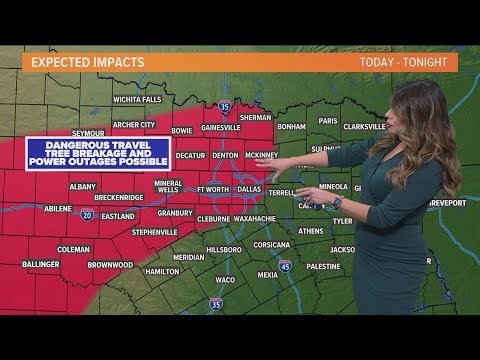
glaze. Sometimes it looks like the road is dry when this happens, but that’s not the case. It’s very slick. This is issued when more than 1/4 inch of ice accumulation is expected and that is the case today and tonight. Accumulation of ice can make trees and utility lines sag walking in. This will be dangerous and driving will be extremely dangerous. During these circumstances, so this is the area again where that ice storm warning is, this is where we could see dangerous travel, tree breakage and as a result, possible power outages from those sagging lines. That’s
because accumulations of up to 1/2 of an inch of ice will be possible on the outskirts of that warning, winter storm warning continues. This is where we’ll see ice covered roads and maybe even some power outages as well. So that’ll be something to watch. And of course the timing also incredibly critical. Greg, what does that look like? Yeah, that timing with that, we are talking about what will likely be a freezing rain event across our area as we go through the day. So let’s work, you work our way through that. As we head toward mid
late morning, it starts to pick up, you see, around 10:00 AM as we get in around the Metroplex, we’re gonna start to see a little bit more of that freezing rain around the area, our Northwestern counties as well under that the ice storm warning that the Marielle just talked about. You see how widespread it will be around 4:00 o’clock. And then as we head towards 7:00 PM, still looking at more freezing rain across the area, the freezing line begins to creep a little farther to the West and we’ll get more of that. Mixture of rain
and freezing rain after midnight and by tomorrow morning temperatures should be hovering right around freezing. So more of rain and freezing rain mixed in before we get that transition over to all rain, we think as we head toward the midday on Thursday, temperatures finally get above freezing. That might not be until 9:00 o’clock or so as we head into tomorrow morning. So you see the temperatures as we head into this afternoon still right around 3031 degrees even by late this afternoon, even heading into the evening hours. But then as we head into the overnight after
midnight, we may finally climb. Above freezing across the area, so hopefully we get more of that to rain mixed in as we head into the overnight hours. Maybe not as big a problems on those roads as we head into tomorrow.