In the Tropics: Tropical Storm Warning issued along East Coast
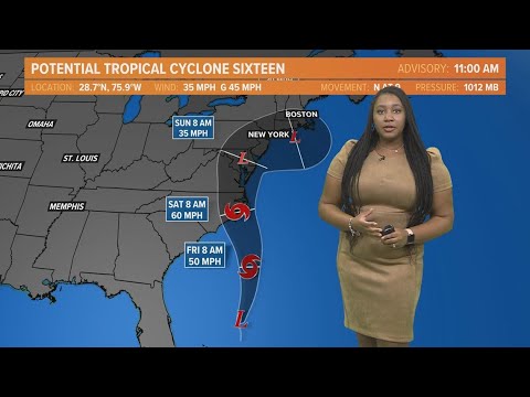
Good afternoon. I’m meteorologist Taylor Steffensen with 13 news. Now, here’s your tropics update as of September 21st at 1 p.m. We’re keeping our eyes on the tropics. There’s hurricane Nigel, but our bigger concern is going to be this low pressure system trying to develop off of the southeast coast. Now, the hurricane center has put a track on this system right now. Potential tropical cyclone 16 forecasts game subtropical characteristics over the next day or so. What that means is that it’s basically going to be a hybrid between a low pressure system and a tropical system. So
drier air on one side, tropical air on the other. Then right before landfall, somewhere between Friday and Saturday morning, we may see this become a tropical cyclone, meaning that it’s going to have tropical air in moisture all around that center for has to strengthen to 60 MPH somewhere near the east coast of North Carolina. Now, regardless if this gets a name it or not and if it does get a name, it would be Ophelia, the impact stay the same. So do not rely on just the naming system. Everything stays the same in terms of indirect
impacts to Hampton roads and northeast North Carolina. That being said we underneath a tropical storm warning anywhere from the eastern shore all the way through Hampton roads and
be possible across the area, but they’re going to be light and brief in nature. The heaviest rain starts to move in as we head into Friday morning and it’s going to roll in from south to north across our area. We also will see gusty winds. That is why we are underneath that tropical storm morning. We could see some wind gusts up to 40 to 50 miles an hour starting on Friday. Heavy rain started to move through our area really around Friday evening. So dinner time, of course, our area very prone to flooding. So we’ll keep
an eye out for flash flooding starting on Friday into Saturday morning and even some parts lasting until Sunday morning as well. Saturday morning. We’re going to switch from really a lot of widespread rain to occasional to scattered showers across the area. But still that risk for some heavy downpours, possible drier conditions start to roll in really late on Saturday and into Sunday morning. So we will also keep a few clouds, but at least the majority of the rain will be gone by Sunday morning. Now, your five day rainfall forecast shows the further you live closer
to I 95 the less rain you may see. So we’re talking only about 1 to 2 inches along the I 95 corridor. As you head towards the seven cities, we’re talking anywhere from Norfolk to possibly Virginia Beach. We’re talking 2 to 4 inches of rain. Again, heavy, local, heavy, local downpours are possible. So we could see some of those rainfall totals just locally higher in some places. But a good consensus for the eastern shore says that we could see rainfall totals four inches plus in some areas. So again, we are underneath that potential for flash
flooding possible around that I 95 corridor east of that corridor. We’re talking very possible and that continues again from Saturday morning through Sunday morning as well. Very possible to see some of that flash flooding. So if you encounter any of these flooded roadways, please turn around. Don’t drown, try to take an alternative route. We don’t want you to be at risk and we don’t want you to put first responders at risk as well. Now, we also are keeping an eye out for the impacts along the coast itself. We’re talking rip current risk and high surf
and even the potential to see some storm surge, we could see up to 4 ft of storm surge across parts of our coast from the eastern shore all the way down into the outer banks. But wave heights are going to be particularly interesting because we could see some of those wave heights by Friday afternoon, up to about 9 to 12 ft rising through Saturday up to potentially 15 ft for us. But as that center of circulation starts to move out of our area and we start to see clearer skies, we will see that surf start
to go down once again by Sunday evening. So we are predicting a moderate flood stage for ties at Sewell’s Point, especially with high tides and the astronomical tides across our area for your town. We are expecting major flood stage and then for duck, we’re encountering some of that minor flood stage and then dying down as we head into Saturday night, your current risk for Thursday and Friday will remain high. So if you do plan to go to the beach, at least for today, since it will be a quieter day, I would not recommend going out
into the water just enjoying the sand for today. But again, recurrent risks are forecast to at least be moderate to high for Saturday as well. Now, we also are keeping an eye out for hurricane Nigel, not forecast to really go towards any types of land for right now, basically a fish storm but still a category one with sustained winds of 85 miles an hour with gust up to 100 five weakening as it heads over cooler waters in parts of the northern Atlantic. The last thing we’re looking at is an area that could develop into a
tropical system. A wave emerged off of the coast of Africa. It has a 70% chance of development over the next seven days. For more information on the tropics and direct impacts to Hampton roads and northeast North Carolina head to 13 news now dot com for 13 news. Now, I’m meteorologist Taylor Stinson.